


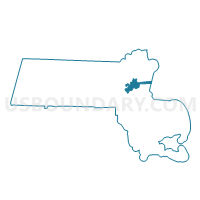
Boston Ward 17 Precinct 14, Suffolk County, Massachusetts
About
Outline

Summary
| Unique Area Identifier | 595387 |
| Name | Boston Ward 17 Precinct 14 |
| County | Suffolk County |
| State | Massachusetts |
| Area (square miles) | 0.15 |
| Land Area (square miles) | 0.15 |
| Water Area (square miles) | 0.00 |
| % of Land Area | 97.97 |
| % of Water Area | 2.03 |
| Latitude of the Internal Point | 42.27297530 |
| Longtitude of the Internal Point | -71.07415890 |
Maps


Graphs
Select a template below for downloading or customizing gragh for Boston Ward 17 Precinct 14, Suffolk County, Massachusetts


Neighbors
Neighoring Voting District (by Name) Neighboring Voting District on the Map
- Boston Ward 17 Precinct 12, Suffolk County, MA
- Boston Ward 17 Precinct 13, Suffolk County, MA
- Boston Ward 18 Precinct 1, Suffolk County, MA
- Milton Precinct 3, Norfolk County, MA
- Milton Precinct 6, Norfolk County, MA
Top 10 Neighboring County Subdivision (by Population) Neighboring County Subdivision on the Map
Top 10 Neighboring Place (by Population) Neighboring Place on the Map
Top 10 Neighboring Unified School District (by Population) Neighboring Unified School District on the Map
Top 10 Neighboring State Legislative District Lower Chamber (by Population) Neighboring State Legislative District Lower Chamber on the Map
Top 10 Neighboring State Legislative District Upper Chamber (by Population) Neighboring State Legislative District Upper Chamber on the Map
Top 10 Neighboring 111th Congressional District (by Population) Neighboring 111th Congressional District on the Map
Top 10 Neighboring Census Tract (by Population) Neighboring Census Tract on the Map
- Census Tract 4164, Norfolk County, MA (6,069)
- Census Tract 1008, Suffolk County, MA (5,546)
- Census Tract 1010.02, Suffolk County, MA (4,979)
- Census Tract 4163, Norfolk County, MA (4,749)
- Census Tract 1009, Suffolk County, MA (4,072)